|
Our GIS solution can be based on customers maps or Tele Atlas maps or Monolit maps. Many layers of data can be added to above mentioned maps.
- BMP .bmp Windows bitmap
- ECW .ecw ERMapper Wavelet compressed.
- WMF .wmf Windows Meta File
- GIF .gif
- JPEG .jpg, .jpeg
- KML / KMZ Google Earth KML / KMZ.
- PNG .png Portable Network Graphics
- TGA .tga Targa
- TIF .tif
- TIFF .tif GeoTIFF
- DXF .dxf AutoCAD
- E00 .e00 ESRI Arc Info
- KML / KMZ Google Earth KML / KMZ.
- MIF .mif MapInfo mid/mif
- SHP .shp ESRI ArcView, including 3D
The GIS solution can be upgraded to vehicle tracking system. For this purposes customers specific solution can be tailored or general purpose site quicktrac.net can be used.
|
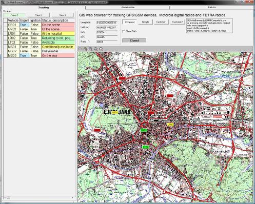
GisWebBrowser is an application that enables tracking location of vehicles, persons or goods. The information on location can be obtained by the varieties of media such as:
- GPS tracking devices with SMS/GPRS/EDGE/UMTS/HSDPA/HSUPA,
- professional analogue mobile radio PAMR (e.g. Motorola GM360),
- digital mobile radio DMR (e.g. Motorola DP3601),
- TErrestrial Trunk RAdio TETRA (e.g. NOKIA THR880i).
GisWebBrowser benefits:
- display all your vehicles locations on the map in real time,
- track and trace the nearest vehicle to the client address,
- control route history (length, start, stop duration, max speed, average speed),
- control if a vehicle enters or leave a specific area,
- dispatcher can keep in touch with drivers in real time,
- monthly, weekly, daily reports.
|